
|
|
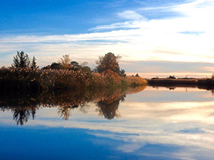
The Manumuskin River
The Manumuskin became the focus of considerable attention on February 14, 1986, when the Hazardous Waste Siting Commission included an area adjacent to it on its list of five potential sites for a toxic waste entombment facility. While that site was delisted in June of the following year as a result of intensive field studies which testified to the environmental sensitivity of the targeted area, subsequent efforts on the part of Maurice River Township and Cumberland County to include the tributaries: the Manumuskin, the Menantico, and the Muskee; and the main river, the Maurice, in the federal Wild and Scenic River program have kept the spotlight on this river system. On December 1, 1993 President Bill Clinton signed the legislation approving its designation as Wild and Scenic, and on October 26, 1994 Vice President Al Gore presided at a celebration on the banks of the Maurice to commemorate the establishment of a local management plan for the rivers as the last step in the Wild and Scenic process..
In 1988, a study conducted by the New Jersey Conservation Foundation, called Conservation Plan for the Manumuskin River Watershed, had this to say:
"The Manumuskin drainage basin lies within the New Jersey Outer Coastal Plain, the Delaware Bay estuary system, and the Pine Barrens forest region. From its headwaters in southwestern Atlantic County, ... the Manumuskin river flows in a southerly direction for 12 miles, emptying into the Maurice River, about 7 miles from Delaware Bay. The river becomes tidal at a point three miles upstream of its confluence with the Maurice River.
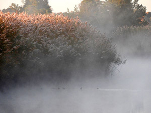
...The lowland vegetation includes Atlantic white cedar stands and hardwood swamps. Extensive logging and subsequent replacement by hardwoods has dramatically reduced the extent of the cedar. Pitch pine occurs in transition areas...There are also some wetlands formed by excavation and impoundments, including former bogs once flooded for cranberry farming. Of special interest are the vernal ponds... . Aside from harboring specific rare plants and animals, these vernal ponds are themselves a rare community type. A portion of the state's largest wild rice wetlands extends into the tidal portion of the Manumuskin from the adjacent Maurice River.
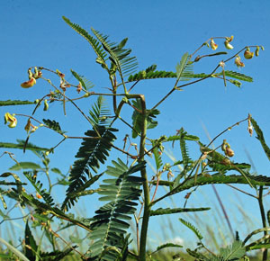
... Thirty-two rare plants were known to be extant in the drainage basin in 1987, making it one of the most botanically significant areas in New Jersey. One plant [the sensitive joint vetch, or aeschynomene virginica] is found nowhere else in New Jersey [and is the largest of only five known populations world-wide], and at least five globally endangered species occur. Many other rare plants may also be present.
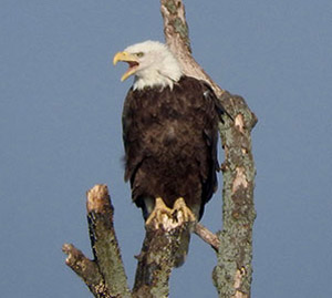
"The reptile and mammal diversity is extraordinary, reflecting the excellent water quality and undisturbed nature of the area. The state' s largest and perhaps only population of the Northern Scarlet Snake is found here [together with significant populations of the Northern Pine Snake and the Corn Snake, both on the Threatened and Endangered list]. ...The Manumuskin has extreme ornithological significance for New Jersey. Fifteen of New Jersey's twenty-five threatened and endangered species of birds are breeding in the basin. Wintering waterfowl and raptor populations, particularly the bald eagle, are among the greatest in New Jersey and comprise what is probably the largest concentration of these birds in the state using land not currently in public ownership."
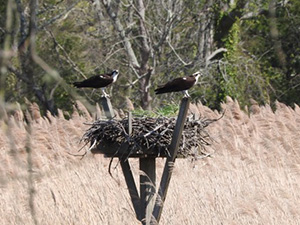
Our trip will begin at Minnamuska Creek Farm, near the Manumuskin's confluence with the Maurice. When I first built this website, we had lived here for over twenty years, and had recently included approximately 17 of our 19 acres in the state Forest Stewardship program. Directly across from our dock is an osprey nest, one of an ever-increasing number erected by Citizens United to Protect the Maurice River and Its Tributaries. “Our" nest has successfully fledged chicks for over 25 years now.
From our dock we will travel upstream, showing you the first tender shoots of the abundant stands of wild rice which have provided food for migrating birds of all types in the autumn. In the summer and early fall the marshes are bright with a succession of purple pickerelweed, pink mallows, yellow tickseed, red cardinal flowers, and the lush green of arrow arum. Once past the last houses you will see, to your left, the 3000 acre parcel originally known as the Warner Tract, which was the target site for a hazardous waste entombment facility and subsequently the subject of litigation between Waste Management Inc. (the owner), the Maurice River Township Planning Board and Township Committee, and, later, several conservation groups which sought to protect the site from further mining and other uses viewed as having the potential to impact adversely on the environment. This litigation was dropped when The Nature Conservancy purchased the land to protect it. Since that time the State has acquired the property for conservation and recreational purposes.
On both sides of the river, stands of the globally-endangered sensitive joint vetch will soon be rising taller than the surrounding vegetation, covered with tiny yellow flowers and, in the fall, festooned with the typical legume-like seedpods. When it is a good year for a. virginica the plants are widespread. Since it is an annual, the extent of this plant varies. Sometimes it is plentiful, and at other times only a few meagre stands can be seen. The presence of sensitive joint vetch is due to the unusual purity of the water in the upper Manumuskin; it is one of only two pristine streams in the Pinelands National Reserve. Its purity is a result of the almost complete absence of development of any kind as well as the exceptional filtration provided by the unbroken hardwood forests that descend to the tidal marsh or the creek bank itself.
If the tide permits, we will ease under the railroad bridge and show you the upper Manumuskin, characterized by a freshwater plant community and fringed with red and white oaks, black walnut, swamp maples, sourgum, and other lowland trees which come up to its edge. Here we have heard young redtails, crying for their parents who have migrated ahead of them, and a host of warblers, bluebirds, yellow-billed cuckoos, and cedar waxwings. Black ducks congregate to find shelter from hunters in the autumn, and pickerel and large-mouthed bass live here, hiding under the shadowy hummocks of grasses.
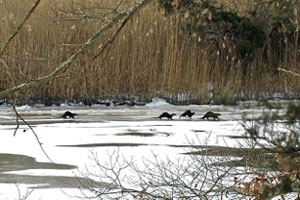
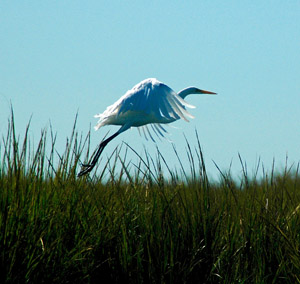
During the summer, notable sights and sounds along the river system include the bubbly song and clever hanging nests of the marsh wren, which builds several potential bowers for its mate. These look like tangles of dried grasses wrapped, approximately three or four feet above ground level, around a phragmite stalk or a cattail. Great blue herons, belted kingfishers, bluebirds, redtails, Cooper's, and sharpshinned hawks, bald eagles, green herons, snowy and common egrets, redwinged blackbirds, cedar waxwings, yellow-billed cuckoos, orchard and Baltimore orioles, least and Forster's terns, yellowlegs, black and wood ducks, and many species of warblers are among the birds which can be seen and heard along the river corridor. Otter also live here, and can be seen sliding down icy riverbanks through thickly falling snow on a late winter's afternoon, as well as herding their young upstream in family groups of seven or more on a hot summer day. As you can see, the Manumuskin is a real treasure; the knowledge that significant portions of it are being dedicated to conservation is a great relief to all those who have fought numerous battles to protect it.
Heading out of the Manumuskin and into the Maurice River, a swing right takes us upriver toward the Menantico. We motor past the old Fralinger farm with its red brick dairy barn, a remnant of a time when farming was practiced extensively along the river banks. The Fralinger oxbow holds the area's first manmade osprey nest, which has been tenanted successfully for many years. Farther along, the Menantico River mouth appears just to the right of the Burcham Farm. Once farms lined the river, protected by a system of dikes which held tidal flow so that the marshland could be drained. Barges pulled by horses once moved along the diked paths. Gradually, with the advent of commercial fertilizers, the rich marshland was no longer in demand and it was cheaper to let the dikes go. The Burchams', with its red - walled homestead built in 1860 from bricks made in kilns on site, is the last of the diked farms, and is still being worked by the same family which reclaimed it from the marshes over a century ago.
The Menantico River
Veering to the right, our boat slips into the Menantico River. We have planned our trip for high tide because of the multiple snags which lie under the surface to catch the unwary. However, if the river is too high, it's difficult to fit under the bridge which carries Route 47 across the water. The Menantico is primarily a freshwater river, and the tidal influence affects the level but does not have as strong an impact on the vegetation as is seen on the lower rivers. Deciduous trees grow down to its banks along most of its navigable length, and a series of freshwater lakes provides excellent fishing for the small boats which can travel that far. Deep scarlet cardinal flowers add colorful accents in late summer, egrets fish in its waters, kingfishers hunt up and down the river bends, announcing their presence with a busy rattling call, and redbellied turtles are numerous, slipping off logs or banks silently as our boat approaches.
The Menantico is a wonderful river for canoes, and the foliage is beautiful in the fall. In our motorboat we make our way under the Route 55 bridge and continue on up the stream. In our smallest boat we can go under the old railroad bridge and make our way into the string of lakes. However, today we turn around and head back downriver to the Maurice.
The Maurice River
The Maurice begins in Gloucester County, fifty-eight miles from its mouth at the Bay, and flows south, forming the eastern boundary between Salem and Cumberland Counties. From the dam in Millville to the Delaware Bay, the Maurice River is approximately twenty miles long. According to the May 1992 Draft Report of The Maurice River & Its Tributaries National Wild and Scenic River Study, the Maurice functions as an important biological link between its unique drainage area and the Delaware Bay. Extremely high quality water is delivered to the Bay by the system, a critical factor for the regional oyster, crab, and fin-fish industries, which have been important culturally and economically in this area for at least five generations. The Draft Report goes on to state:
"It is the overall biological integrity of this river system, especially relative to the Delaware Bay's sources of water and pollution, that makes it important... The Delaware Estuary is recognized as nationally significant...[It] has been nominated to the Convention of Wetlands of International Importance, also known as the Ramsar Convention of 1971....Within the context of the Western Hemisphere, the study area functions as critical migration-related habitat for shorebirds, songbirds, waterfowl, raptors, rails and fish.... The Maurice River and its tributaries drain the southwest portion of the Pinelands National Reserve, which is also an International Biosphere Reserve under the United Nations Man and the Biosphere Program."
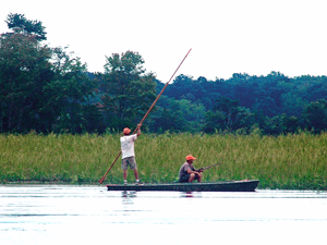
Just south of the mouth of the Manumuskin River flat-bottomed boats are beached on a small landing. These are used for rail bird hunting, and are poled along through the marshes in search of king, sora, and clapper rail. Teddy Roosevelt was the most famous rail bird hunter to come to this area for the purpose. Philadelphians with famous names arrived in limousines to enjoy the sport, and Thomas Eakins is reported to have visited here as well.
At Bricksboro the Muskee Creek joins the larger river. The tide is against us and we won't attempt an exploration today. However, once past the towering walls of phragmites the Muskee becomes a small stream which runs through salt marsh and then into tangles of deciduous bushes and trees. One day, exploring it by canoe, we flushed a wood duck in full colors. As it flew up it riveted the attention of a passing female Cooper's hawk, which performed a midair barrel roll and dropped swiftly to seize its prey. Because the drama played itself out below the level of the phrags we never knew which was victorious, but we were awed by the fierce acquisitiveness of the Cooper's, with its attempt to take on so large a prey.
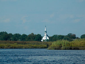
Further south and on the opposite shore of the Maurice is the little village of Mauricetown, where a metal bridge, now replaced by a modern concrete span, was once tended by a bridgekeeper who cranked it open by hand whenever a large vessel required passage. The tall white steeple of the Mauricetown Church can be seen up and down the river, and was doubtless a beacon to sailors when the river was a busy port. Once upon a time Mauricetown was the home of oyster captains who kept their tall-masted schooners moored near the bridge, in the fresher water of the upper river, to avoid barnacle encrustation on their hulls. The town has undergone a revival of late and is now known for its antique shops and charmingly restored Victorian homes, painted in a variety of colors.
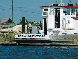
Past Mauricetown, across the river in Maurice River Township, is Dorchester. Its active shipyard is one of the last continuously operating deepwater marine repair and ship building facilities on the eastern coast. South of Dorchester and its sister town, Leesburg, are the marinas, located on the highlands between the marshy oxbows of the meandering river. Near the mouth of the river on the Commercial Township side are Shellpile and Bivalve, with their fleets of oyster and crab boats and their obvious historical dependence on shellfish. The Cashier, which up until recently could be seen moored among the other dis-masted and motorized oyster schooners, was one of the oldest working vessels in the country, having been built in 1847.
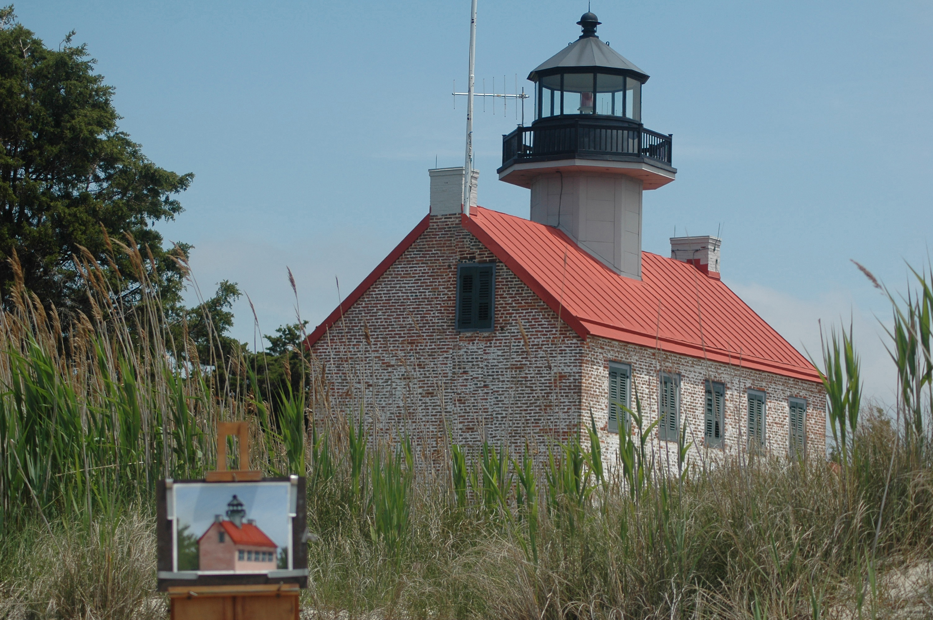
Past Bivalve is the Bay, and the red-roofed, brick lighthouse. East Point Light was commissioned in 1852 and transferred to the state of N.J. in 1956. Restoration was begun by the Maurice River Historical Society in 1971. Of the four lighthouses along the Bay in Cumberland County, only East Point remains. Just down the coast is the village of East Point. Along with Thompson's and Moore's Beach further south, it is a stage on which a major shorebird drama plays out in the spring, when red knots, sanderlings, ruddy turnstones and such arrive at the end of a four to six-thousand mile journey from South America to feast on the eggs of the horseshoe crabs, which literally cover the beaches, in order to fuel up for the last leg of their migratory journey to the Arctic tundra. In the winter, bald eagles use the Maurice extensively, and on one memorable day seventeen individuals were spotted in the area, perching or actively hunting for dinner.
As you can see, the Menantico, Manumuskin, Muskee, and Maurice provide an environmental, cultural, and historical diversity which are unparalleled.
|